|
|
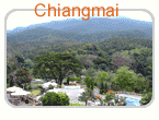
Travel Infomation about Chiangmai, Thailand |
|
Popularly known as the Rose of the North, Chiang Mai is blessed with stunning natural beauty and unique indigenous cultural identity. Founded by King Mengrai the Great as the capital of the Lanna Thai kingdom by merging the various city-states in the region in 1296. Today Chiang Mai is the economic, communications, cultural and tourism centre of Northern Thailand. |
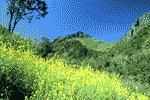
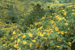
About 700 kilometres from Bangkok, Chiang Mai is situated on the Mae Ping River basin some 310 metres above sea level. Surrounded by high mountain ranges, it covers an area of approximately 20,107 square kilometres. The terrain is mainly jungles and mountains, parts of which are within national parks which are still fertile and verdant with plentiful flora and fauna. There are many sites and locations where tourists prefer to visit to study the lifestyle of the tribal people who live on high hills.
Distances from town to neighbouring districts
|
| |
Chom Thong
Chiang Dao
Chai Prakan
Doi Tao
Doi Saket
Fang
Phrao
Mae Chaem
Mae Taeng
Mae Rim
Mae Wang
Wiang Haeng
Samoeng
San Kamphaeng
San Sai
San Pa Tong
Saraphi
Hang Dong
Om Koi
Hot
Mae On
|
58 km
68 km
13 km
121 km
18 km
km
103 km
156 km
40 km
8 km
35 km
150 km
54 km
13 km
12 km
22 km
10 km
15 km
179 km
88 km
29 km |
HOW TO GET THERE
By Car
a) From Bangkok drive on Highway No.1 (Phahonyothin) to Highway No.32 passing the provinces of Phra Nakhon Si Ayutthaya, Ang. Thong, and Nakhon Sawan, then take Highway No. 117 to Phitsanulok and drive on to Highway No. 11 to Lampang, Lamphun and Chiang Mai. The route is 695 kilometres.
b) From Bangkok drive to Nakhon Sawan and then take Highway No. 1 passing Kamphaeng Phet, Tak, Lampang, and Chiang Mai. The route is 696 kilometres.
|
|
By Bus
The 10-hour journey from Bangkok can be made on air conditioned buses originating from the Northern Bus Terminal (Mo Chit 2), contact tel. 936 2852 for more information. Buses leave for Chiang Mai several times a day from 8.00 to 21.00 hrs.
|
There are services from Chaing Mai’s Chang Phuak Bus Terminal to various districts in Chiang Mai. Buses ply along the northern route (Highway No. 107) passing Mae Rim, Mae Taeng, Chiang Dao, Chaiprakan, Fang and Mae Ai. Some buses continue to Tha Ton. Local city buses ply between Chiang Mai and Lamphun on Highway No. 106.
By Rail
The State Railways of Thailand operates daily services from Bangkok Railway Station (Hua Lamphong). Trains leave for Chiang Mai 6 times a day from 8.00 – 22.00 hrs.
By Air
Thai Airways operates daily flights from Bangkok to Chiang Mai.
Getting Around
For relative short distance you can take a tricycle (Sam Lor). Short rides within the city cost between 20 and 30 baht. Longer rides may cost as much as 50 baht.
Tuk-Tuks (three-wheeled motorised taxis) are also popular for short and quick journeys. Fares must be bargained in advance. Minimum fares and approximately 20 baht.
The most common means of transport is a “See Lor” (literally “four wheel”) or “Song Theao” . They all are red-coloured and look like pick-up trucks but with a roof over the back. They pick up as many passengers as they can and drop them off as the drivers reach their destinations. To go by “See Lor”, simply tell the driver your destination. Fares range from 10-20 baht according to the distance.
|
|
CITY ATTRACTIONS
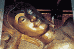
Wat Suan Dok is on Suthep Road. The temple was built in a 14th century Lanna Thai monarch’s pleasure gardens and is a favourite for photographers, particularly for striking sunset. Several of the white chedis contain ashes of Chiang Mai’s former royal family. The 500-year-old bronze Buddha image in a secondary chapel is one of Thailand’s largest metal images.
|
Wat Chiang Man is Chiang Mai’s oldest temple and probably dates from 1296. King Mengrai allegedly lived here while the new city of Chiang Mai was constructed. Road. It is noteworthy for a chedi supported by rows of elephantine buttresses and a beautiful chapel. Enshrined in the temple are a tiny crystal Buddha called Phra Kaeo Khao, which is thought to have the power to bring rain. Another image, called Phra Sila Khao, reflects the fine workmanship of Indian craftsmen from thousands of years ago.
Wat Phra Sing, located on Sam Lan Road, houses the revered Phra Phuthasihing Buddha image cast in Subduing Mara. The Buddha image is now enshrined in Vihan Lai Kham. During the Songkran festival, each April 13-15, people process the most sacred Buddha image around Chiang Mai town for traditional bathing. Formerly, this area was a Wat Li Chiang Market (Li means market) until 1345, King Pa Yu, the fifth king of Mengrai Dynasty commanded to built this temple and a 24 – feet chedi containing his father’s ashes. The temple compound includes the lovely Lai Kham chapel featuring exquisite woodcarvings and northern-style murals, a magnificent scriptural repository with striking bas relief, and a circular stupa (in Lankan bell shape).
Wat Prasat, located on Intawarorot Road near Wat Phra Sing. The temple houses traditional Lanna architecture chapel, the chapel roof is decorated in colourful glasses and wooden craved lions. Wat Prasat houses one of the rare Lanna art’s Buddha image.
Wat Chedi Luang houses the largest chedi in Chiang Mai. The temple is located right in the middle of the city and was built in the reign of King Saen Muang Mak, the seventh king of Mengrai Dynasty. The 98-metre tall and 54-metre wide chedi was built in the reign of King Tilokkarat. The consturction was completed in 1481. In 1545 the chedi was collapsed due to an earthquake during the reign of King Jiraprapa. The chapel in the front was built by Chao Khun Uba Lee Poramacharn (Sirichantathera) and Chao Kaeo Navarat in 1928.
The magnificent methodological serpents ramble from the entrance of the chapel to its door on both sides. It is believed that they are the most beautiful manmade serpents in the north of Thailand.
Sao Inthakil or Sao Lak Muang , the city pillar was built when the founder of Chiang Mai, King Mengrai governed the city in 1296. It is located in front of Wat Chedi Luang and enshrined in a small Thai chapel.
The pillar is made of log and kept underground. The Khao Inthakil or city pillar celebration is held annually in May.
Wat Phan Tao, located on Phra Pok Klao Road beside Wat Chedi Luang. The temple was a throne hall for king Mahotara. Prateth, thus the peacock shaped doors were built. It is believed that peacock is a symbol of king.
|
|
Wat Ku Tao , it was formerly called Wat Veru Vanaram. The temple is located in Tambon Sri Phum near Chiang Mai Satdium. It is noteworthy for an unusual watermelon shaped pagoda, thus giving such name by the locals. An exact period of its establishment is somewhat unknown, but from a legend, the Ku Tao chedi contains ashes of Prince Saravadee, the son of King Bureng Nong who ruined Chiang Mai from 1579 to 1607. |
Wat Saen Fang, is located on Tha Phae Road. This is the old temple, built in the Burmese architecture. The residence of the abbot dating from more than 100 years is an interesting attraction in the temple compound. King Intavitchayanontha, the seventh king who governed Chiang Mai commanded to destroy the residence of Phra Chao Gavirorossurivongs (Chao Chevit Ao), the sixth ruler of Chiang Mai.1877, later his former residence was rebuilt in this temple. The celebration was held in 1878.
Wat Buppharam, located on Tha Phae Road, Muang district. The interesting attractions include the Burmese architectural chedi, the wooden craved roof main chapel, and the local style wooden small chapel.
Wat Chedi Liam or Chedi Ku Kham , the temple was built in 1288 in the reign of King Mengrai after he had authorised an administrative responsibility of Lamphun town to his minister, Aey Fah. King Mengrai established a town in the northeast of Chiang Mai for 5 years and then resettled a town near the Mae Ping River in 1277 and renamed it “Wing Kam”. In 1287, the stupa of Wat Jamthewi, Lamphun was rebuilt in Wieng kum Kam for the locals to worship.
After that for hundreds years, the temple was left abandoned. In 1908, a Burmese tycoon renovated it, thus the temple has influences of Burmese architecture instead of its former Khmer style. Only some parts were rebuilt in Khmer architecture.
Wat Chedi Chet Yot or Wat Photaram Vihan, located on the Super Highway Road (Chiang Mai-Lampang), 4 kilometres from Chiang Mai town. It is one of the oldest temples in Chiang Mai and was recently renovated. The interesting attraction of this temple is the seven tapering finial stupa, which is supported by lovely divine sculptures at its base. The most interesting of all is that the stupa possesses architecture of the Phuttakaya stupa in India. Besides, the stupa contains ashes of King Tilokkarat, the king of Mengrai Dynasty who built this temple is worth a visit.
Chiang Mai National Museum is located on the Chiang Mai-Lampang Super Highway near Wat Chet Yot. The distinctive building was built in modern Lanna Thai architecture and features northern arts and culture. The area is peaceful and refreshing. It is open from Wednesday to Sunday, 09.00-16.00 hrs. and closed on Mondays, Tuesdays and the national holidays.
Wat U Mong, located on Suthep Road in the town. The spacious temple was found in the reign King Mengrai around 1296, It renovation was done in the reign of King Keu Na. The large wall like building with a connected tunnel inside is a remarkable piece of art is located in the temple compound. A large stupa is located near the temple’s wall. Wat U Mong is teemed with various kinds of trees, thus making it an ideal meditation place.
Kad Suan Kaeo Art & Cultural Centre , located in Kad Suan Kaeo Shopping Mall. As the name indicates, it is a centre of art and cultural performances. The Kad Suan Kaeo theatre is equipped with advanced technology where numerous Thai and foreign shows are performed.
Insect and Natural’s Wonders Museum has fascinating collection of domestic and foreign insects including animal fossils. It is located at 72 Nimmanhemin, Soi 12 (Sirimangkhalachan Soi 3), Huai Kaeo, Muang district,
OUT-OF –CITY ATTRACTIONS
Western Route (Highway No. 1004)
|
|
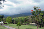
Doi Suthep - Doi Pui National Park, the superb landscaped national park covers an area of 262 square kilometres of Amphoe Mae Rim, Amphoe Hang Dong, and Amphoe Muang. The park consists of verdant forests and mountain ranges. Major Mountains include Doi Suthep, Doi Buak Ha, and Doi Pui. This is a main source of tributaries and streams in Chiang Mai. Sacred places, religious attractions and historical sites are located in park complex. |
To get to the park office, drive from Chiang Mai town for 5 kilometres on the Huai Kaeo-Chiang Mai University-Chiang Mai Zoo route to Wat Phra That Doi Suthep en route to the intersection on the right, the Doi Suthep - Pui National Park road sign will be seen.
Attractions in the Doi Suthep – Pui National Park
Huai Kaeo Waterfall is located 6 kilometres from Chiang Mai town. The 10-metre cascade provides a delightful ambiance of scenic views and various plants.
Khru Ba Siewichai Monument is situated at the foot of Doi Suthep Mountain . The monument honours the devoted Buddhist monk whose followers built the first 10-kilometre motor road to Wat Phra That Doi Suthep in 1935.
Phu Phing Palace is located on the same road, 4 kilometres beyond Wat Phra That Doi Suthep, on Doi Buak Ha. The royal winter palace was built in 1962. The lavishly landscaped gardens and grounds are open to the general public on Friday, Saturday, and Sunday and official holidays, when the Thai royal family is not in residence.
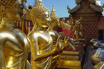
Wat phra That Doi Suthep is Chiang Mai’s most important and visible landmark, and overlooks the city from its forested mountain backdrop. This temple is 15 kilometres from town, 3,520 feet above sea level, and dates from 1383. The temple is approached on foot by climbing a steep Naga staircase comprising 290 steps. The less energetic may ascend by funicular railcars. The temple’s pagoda contains holy Buddha relics, and attracts Buddhist pilgrims from all over the world throughout the year. The temple compound offers an exhilarating view of Chiang Mai city and surrounding countryside. |
|
Doi Pui Tribal Village is a Hmong tribal village some 3 kilometres on an asphalt road from Phu Phing Palace. The village presents the typical lifestyle of the Hmong as well as a scenic view of Doi Inthanon, the highest peak of Thailand. The trip takes only an hour from Chiang Mai town and the village is easily accessible. |
Chiang Mai Zoo is located next to Huai Kaeo Arboretum. It is a well-managed large zoo, which occupies the lower forested slopes of Doi Suthep Mountain. The zoo contains more than 200 types of Asian and African mammals and birds. It is open everyday from 08.00 to 19.00 hrs. Admission fee for adult fee is 100 baht. and children fee is 20 baht. Restaurants and a camping site are available.
Huai Kaeo Arboretum is next to Chiang Mai University. The attractively landscaped garden contains many kinds of tropical trees and lovely flowers. It is best for recreation, exercise, and plants study.
Southwestern Route (Highway No.108)
Wiang Tha Kan is an ancient walled city that dates back to the Hariphunchai period, built before the advent of King Mengrai. During excavations, brown jars with bones and Chinese porcelains from the Yuan Dynasty (1280 – 1368) were found in the area of Tha Kan village. The best preserved of the ruins are the pagoda and the foundations of the vihan, constructed from bricks and laterite. Wiang Tha Kan is located about 34 kilometres to the south of Chiang Mai along Highway No. 108.
Wat Phra That Si Chom Thong is 58 kilometres from the town in Chom Thong district and dates from the mid-1400s. the temple houses a collection of bronze Buddha images, and the secondary chapel contains a holy Buddha relic.
Wat Phra That Doi Noi is in Tambon Doi Lo, Amphoe Chom Thong along highway No.108 between km. 43 and 44. The temple was built by Queen Jamathewi in 658 AD. During excavations, numerous marble Buddha images, Buddha image containers, and a chapel were discovered. The hilltop temple allows visitors to glance the scenic beauty of the Mae Ping River and surrounding hills and valleys. The temple is approachable on foot by climbing 241 steps.
Chiang Mai Cultural Centre at the beginning of Chiang Mai-Hang Dong road has an excellent collection of Lanna Thai art, and displays of traditional northern culture. A spectacular folk dance is performed while the typical northern dinner ‘Khan Tok” is served. The Khan Tok comprises Kaeng Hang Le, a gingery pork curry ; the chilli-tomato-minced pork dip called Nam Phrik Ong ; and the crunchy pieces of pork scratching, or Kaep Mu, for dipping into the rich gravy. Enjoyable tribal shows of Karen, Hmong ,Lahu, Akha, Mien and Lisu are performed after dinner from 19.00 to 22.00 hrs.
|
|
Doi Inthanon National Park is Thailand’s highest mountain and towers 2,565 metres above sea level. Doi Inthanon is a part of the Himalayas , which ranges across Nepal, Bhutan, Myanmar, and ends at Northern Thailand. Complex mountain ranges and a mild climate characterise an area with a moist and dense summit forest. Doi Inthanon is very intersting for ornithologists. Summit forest is the source of important tributaries of the Mae Ping River. Meo and Karen hilltribes inhabit the park. |
Visiting Doi Inthanon is possible throughout the year. The best period for viewing waterfalls is May through November. The best period for viewing wild flowers is December through February . The best period for ornithologists is November through March.
Getting There : Travel 58 kilometres west of Ching Mai via Highway No. 107 to Chom Thong, then turn right into Highway No. 1009 and continue a further distance of 48 kilometres along Highway No. 1009 to the summit. A good asphalt road takes visitors up but is rather steep, thus the vehicle must be in a good condition. Visitors could pay for the entrance fee at Km. 8.
Doi Inthanon can be reached by a local truck (Song Thaeo) from Phra That Chom Thong or Mae Klang Waterfall. The Song Thaeo runs to Doi Inthanon National Park Office (Km. 31) and neighbouring villages. The fare costs 20 baht each. A chartered Song Thaeo costing around 800 baht can make stops at other attractions around the area.
Accommodation, restaurants, and camping sites are available at the park headquarters at Km. 31.
Attractions in Doi Inthanon National Park
Namtok Mae Ya is one of the most beautiful cascades in Chiang Mai. Water flows from a 280-metre steep cliff onto different rock formations in a lower basin like drapes . The well-managed waterfall is teeming with verdant forests and is best for recreation. It is located 1 kilometre from Highway No. 1009 junction, turn left for 14 kilometres and then take a 200- metre walk.
Namtok Mae Klang is a 100-metre one level waterfall located 8 kilometres from Highway No. 1009 junction and turn left onto an asphalt road for 500 metres.
Tham Bori Chinda is a large cave located near Namtok Mae Klang at Km. 8.5 of Highway No. 1009. The road sign to Tham Bori Chinda will be seen at the junction on the right. The deep cave has stalactite and stalagmite formations, Buddha images and a rocky stream, The surface of the water glitters like diamonds flake when light reflects the stream. Sunlight in the cave allows visitors to see the entire cave.
The Tourist Center at Km. 9 has exhibits on nature and animals that inhabit the area.
Namtok Wachirathan is a large waterfall which plummets over the edge of a high cliff into a deep pool below. When there is a large amount of water, there are large splashes in the basin, creating a cool and refreshing environment . The delightful ambience can be felt by walking on a slippery bridge that leads to the waterfall. To get there, turn right off Highway No.1009 at km. 21, then follw the signpost to the waterfall a further 350 metres on foot. At Km. 20 a new read is built to reduce the walk to the waterfall.
Namtok Siriphum is a splendid waterfall that falls from a steep cliff in two lines and can be seen en route to Doi Inthanon. The attractive waterfall is located at Km. 31 of Highway no. 1009 , take a right turn for 2 kilometres and is approachable only on foot from the base of the waterfall.
|
|
Doi Inthanon Royal Project is in khun Klang village close to the park headquarters. The project was initiated in 1979 to help the hill tribes to cultivate cash crops other than opium and train them on modern agricultural practices. Most produces are temperate zone plants. Flower plantations, a plant breeding research lab and flower plantations of hill tribes (Hmong) are open to visitors. |
Phra Mahathat Napha Methanidon and Phra Mahathat Naphaphon Phumisiri, twin pagedas located at Km. 41.5, were built to commemorate the fifth cycle birthdays of King Bhumibol Adulyadej and Queen Sirikit. Both pagodas share the similar bases as well as a two-level walking path that surrounds them. The pagodas enshrine Lord Buddha’s ashes and Buddha images, and overlook the magnificent scenery of Doi Inthanon.
Doi Inthanon Peak has a cool climate all year round. The Air Force Radar Station as well as King Inthawichayanon’s stupa are located on the moutaintop. King Inthawichayanon, the last king of Chiang Mai, was concerned about the importance of forests and wanted to preserve the forests for future generations. He was so attached to the area that he asked that part of his ashes be kept here.
The Tourist Information Centre near the top of Doi Inthanon exhibits a chronological background of the mountain, including its geography, biology, forests, and animals.
Namtok Mae Pan is the longest waterfall in Chiang Mai, which flows from a 100-metre cliff. . Its charm can be enjoyed by standing some distance from the falls. From afar, the white water and the green forests around the falls make for a lovely picture. From Km. 38 of Highway No. 1009, drive along the Doi Inthanon-Mae Chaem road (Highway No. 1192) for 6 kilometres and a sign to the waterfall will be seen, then drive on an unpaved road for 9 kilometres. The lovely waterfall can be reached by a ten-minute walk from a parking lot. In the rainy season, the road to Namtok Mae Phan is in a poor condition; only a four – wheel vehicle could make the journey.
Namtok huai Sai Luang is beyond Namtok Mae Pan, about 21 kilometres from Doi Inthanon-Mae Chaem Road. Turn left to an unpaved road where only a four wheel vehicle could make a trip in the rainy season. The medium size cascade has water all year round and flows from a cliff to each level.
Natural Study trek on Doi Inthanon |
|
Doi Tao Lake is located 133 kilometres from Chiang Mai town along the Chiang Mai-Hot-Doi Tao route. The large reservoir with lush green trees is situated beyond the Bhumibol Dam in Tak province. It was used for agriculture and fishery irrigation. This great body of water offers many recreational opportunities during the rainy and cool seasons, from July to December. Rafting lodge prices range from 1,000 to 1,500 baht. Cruise services to Bhumibol Dam is available during this period. |
Kiu Mae pan starts from Km. 42. This short trail, winding through tallpristine forest for about 2.5 kilometres, a 3-hour wak, allows the hiker to experience the natural beauty of the forest at first hand. The Rhododendrons, commonly found in the Himalayas, are found along the trail and they are in full bloom during December-February.
Trekkers on this route should seek permission from the park headquarters at Km. 31 for safety reasons. A group of not more than 15 people is recommended. Food consumption is not allowed while trekking. This nature trail is closed for reforestation form June l to October 30 annually.
Ang Ka Luang Nature Trail was surveyed and designed by Mr. michael MacMillan Walls, Canadian volunteer biologist who devoted to his work and died from a heart attack on this mountain. This. trail is 360 metres long, passing through wet and cold areas in a lush valley. Forest above 2,000 metres is covered with lichens and wild orchids. Indigenous plants that needs a high level of nutrition, organic deposits, and rare species of birds are seen along the trail.
There are more nature trails on Doi Inthanon, each providing different views of the diversity of plants, reforestation, the importance of tributaries, the origin of caves, hill tribe agriculture, and birdwatching. Walking trails range from 1 to 8 kilometres. Each trip needs approval from the Chief of the National Park and a trekking leader is needed. The service is obtained at the Park Office at Km. 31.
Traditional Cotton Woven Village is located 3 kilometres form Mae Chem District Office in Tambon Tha Pha. The weaving of northern unique style Sarong is made in this tambon (sub-district). Around 150 househoids produce this distinctive cotton. Nowadays, the unique weaving style fabric is in a great demand because of its striking colour and indigenous style. It can be purchased at a low cost for a token of souvenir.
Getting There: Take Chom Thong – Mae Chaem line local truck (Song Thaeo) from Amphoe Chom Thong Market at Wat Phra That Si Cnom Thong and terminates at Mae Chaem Hospital. Operating time is from 09.00 - 17.00. The fare is around 45 Baht. Take a chartered van or Song Thaeo to the village for about 100 Baht.
Wat Phuttha Oen is located in Tambon Chang Khoeng, Amphoe Mae Chaem. According to a legend, this temple was built in an early Ratanakosin period or dating from more than 200 years. One of the most interesting historical attractions in this temple compound is the Water Chapel. The Chapel is surrounded by water battlement instead of the ordinary cement battlements. The Vihan is located behind this water chapel and houses artistic mural painting, but its colour has been faded over time.
Ban Rai Phai Ngam is renowned for its high quality traditional cotton woven. The village is located between km.69 to 70 along Chiang Mai-Hot route, turn left for 1 kilometre to the village. The bamboo shadow along the entrance to this village makes pleasant environment. Presently, villagers who were trained on the natural dyed cotton by the late National Artist, Pa (Aunt) Sang Da Bansit exhibit their artistic cotton woven at her house, which is located beside Mae Ping River. The house has been transformed to a museum showcasing traditional local life style including the works of the founder.
Op Luang National Park is an amazing natural attraction comprising both splendid natural charms as well as mysterious scenery. A zigzagging river flows in front of a picturesque gorge. The area is a high, steep cliff with a narrow passage, creating strong currents and powerful echoes. An area in the north of this stream is teeming with various kinds of plants that provide a pleasant ambience all year round. Magnificent views of Op Luang National Park can be seen from the bridge that links with the gorge. An interesting prehistoric archaeological site is also located in the park.
Getting There: The Op Luang National Park is located 105 kilometres from Chiang Mai town along Highway No. 108 (Chiang Mai-Hot-Mae Sariang). The road stretches alongside the Mae Chaem River and zigzags along mountain ranges. Blue buses originate from the Hot-Mae Sariang roundabout. There are 3 lines of buse: Hot-Mae Sariang, Hot-Mae Chaem, Hot Om Koi. All of them stop at Op Luang National Park.
Hang Dong-Samoeng Route (Highway No. 1269 off Highway No. 108)
Huai Phak Phai Royal Project is at Ban Mae Ha, Tambon Ban Pong, Amphoe Hang Dong along the Samoeng-Hang Dong route. It is some 300 metres from Km. 17. From Chiang Mai, it can be reached via 2 routes : Chiang Mai-Mae Rim-Samoeng-Hang Dong route which is 32 kilometres and Chiang Mai-Hang Dong-Samoeng route that is 43 kilometres. The project is responsible for collecting, researching , and breeding roses. One of the highlighted attactions in this project is the Royal Rose Garden , which covers an area of 8.4 acres. Roses have been planted along mountain ranges. This is where various kinds of roses are found. The best time to visit is from October to February.
A number of pretty resorts that are decorated with highland flowers are located along the route to Huai Phak Phai Royal Project and are open to the public and for camping. Accommodation is available at Kritsada Doi and Utthayan Lanna. Please refer to the accommodation sheet for more information.
Northern Route (Highway No. 107, Chiang Mai-Fang)
|
|
Tribal Museum is in King Rama IX Lanna Garden on Chotana Road. This is an ethnology museum featuring the indigenous culture of 9 hill tribes including Karen (Kariang), Hmong (Meo), Mien (Yao), Lisu (Liso), Akha (Iko), Lahu (Musoe), Lau, Thin, and Khamu including the minority tribe of Malabri. Each tribe possesses unique identity and culture. The museum exhibits ways of life, culture, beliefs, and local wisdom of those tribes, which have been intellectually conveyed through artistic objects displayed in the museum. It is open daily to the public from 09.00 to 16.00 hrs.
|
Tham Chiang Dao is a charming cave located in Amphoe Chiang Dao. It is situated 72 kilometres from Chiang Mai town, turn left at the entrance route and proceed for 5 kilometres on an asphalt road. Convenient parking is available. Climb a staircase with a zinc roof to reach the cave. The lovely cave greets visitors with various kinds of fish swimming in a stream in front of the cave. Touring in and around Tham Chiang Dao with a local guide is possible by contacting local guides in front of the cave. A service fee is charged.
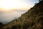
Doi Luang Chiang Dao is a limestone mountain in the Chiang Dao Wildlife Reserve area, Amphoe Chiang Dao. This cone-shaped mountain is 2,195 metres from sea level, which makes it the third highest mountain in Thailand after Doi Inthanon and Doi Pha Hom Pok. Narrow plains on top of the mountain overlook spectacular views that include a sea of fog on the Amphoe Chiang Dao side, Doi Sam Phi Nong, the Chiang Dao mountain range, and the far end of Doi inthanon. The peak is cool and windy. It is full of rare highland flowers, birds, and butterflies. Visiting Doi Chiang Dao needs an approval letter from the Director of Wildife Reserve Division, Royal Forest Department. It must arranged at least 2 weeks before traveling. Contact tel. 561 – 2947 for more information.
Getting there : The peak is accessible on foot. At Chiang Dao cave, guides, porters, and charterd transfers to the starting point of the t rail are available. There are no tourist facilities on Chiang Dao Mountain. Visitors must bring their own sleeping bags, food, and water.
Descending the mountain is possible on the trail near Ban Tham, which is located near Chiang Dao cave. The trail is rather steep; nevertheless, it could shorten the walking distance upon descending . It is quite difficult to climb up.
Wat Tham Tap Tao is in Amphoe Chaiphrakan on the Chiang Mai-Fang route. Take a left turn at an intersection for 3 kilometres. The temple is situated between Km. 120 and Km. 121. The peaceful temple compound comprises a mid-pond scripture hall and Tap Tao cave, which is the beauty highlight. The cave is somewhat smaller than Chiang Dao cave, but it offers the unique charm of Buddha images inside.
Doi Ang Khang is on Highway No. 107 (Chiang Mai-Fang) . Turn left at an intersection around Km. 137 (at Mae Kha Market) and proceed to Doi Ang Khang for a further distance of 25 kilometres. It is a steep zigzagging asphalt road. Therefore, only vehicles in good condition and experienced drivers can make the trip. The local truck (Song Thaeo) from Mae Kha Market offers chartered service to the splendid mountain . The area has a cool climate all year round, particularly from December to January, when much of the area is frosty. During that period, visitors should be prepared to cope with cold weather. Accommodation is available.
|
|
Attractions on Doi Ang Khang
Ang Khang Royal Agricultural Station is a demonstration site for planting and resarching flowering plants, temperate fruit trees, vegetables and other crop under the patronage of His Majesty King Bhumibol Adulyadej.
|
Bonsai Garden is located in front of the station. The garden comprises temperate and winter plants of Thailand and overseas, all of which are decorated, cut and planted with the Bonsai technique. Touring around Bonsai garden, visitors can also see herbal plantations. The best time to visit is from November to January.
Mu Ban. Khum is a village located near the Royal Agricultural Station. It is a small community comprising people of various races such as Burmese, Hwa, and Thai Yai. They settled in the area and run souvenir shops and restaurants.
Kiu Lom Viewpoint is a scenic spot to watch sunrise and sunset including a sea of clouds. It overlooks the delightful ambience of the mountains. On a clear day. the Ang Khang Royal Agricultural Station can be seen from here.
Mu Ban No Lae is on the Thai – Burmese border. The people of No Lae migrated from Myanmar about 15 years ago. They speak their own language and are Buddhists. On every Buddhist day, they stay home to practice the Buddhist precepts. No Lae village offers a magnificent view of natural scenery of the Thai – Burmese border.
Mu Ban Khop Dong is home to Musoes. The tribe believe in ghosts and spirits and still hold on to simple ways of life. The Royal Project has supported this village in promoting agriculture and handicrafts. The Young Local Guide project is underway to guide visitors on the local lifestyle and beliefs, as well as to create a non - migration awareness in local youths.
Mu Ban Luang comprises of Yunnan Chinese who migrated here during World War II. They earn a living from agriculture.
Activities on Doi Ang Khang are varied. Presently, Ang Khang Natural Resort offers the following activities :
- Natural Study Trek, a 2-kilometre trek showing small but beautiful waterfalls and Rhododendron.
- Mountain biking : Ban Khum-No Lae, Ban Luang – Ban Pha Daeng.
- Birdwatching - More than 1,000 species of birds can be seen. The best spots are Mae Phoe forest station and around Ang Khang Natural Resort.
- Mule riding – This is best done by sitting facing sideways because the wide saddle will not allow a horseback – riding style. Booking must be done at least one day in advance with the resort as mules are normally used to carry agricultural produces.
Fang Hot Springs is at Ban Pin, which is 8 kilometres northwest of Fang. The 50 hot springs originate from simmering granite with temperatures from 90 to 100 degrees Celsius . The largest spring one s pews out consistent steam with a strong scent of sulphpr.
Tha Ton is a village in Amphoe Mae Ai where the Kok River flows to Chiang Rai town. The lifestyle of the locals living along the river as well as hilltribal villages can be seen during the river trip. Long – tail boat departs Tha Ton daily at 12.30 hrs . , reaching Chiang Rai around 16.00 hrs. The fee is 200 baht per person. A chartered service is around 1,600 baht. Travelling by bamboo raft takes 3 days.
Activities include rafting to hot springs and visiting Lahu (Musoe) village, and elephant riding around the village and forests are available. For more information
Wat Tha Ton occupies an area of more than 160 acres and spreads over several rolling hills. The temple is situated on the bank of the Mae Kok river and offers beautiful scenery. The temple also houses a school for monks, novices, and youths as well as a drug rehabilitation center and a hill tribe support unit.
Mae Rim – Samoeng route (Highway No. 1096 off Highway No. 107)
|
|
Orchid and Butterfly Farms are along the route. Visitors can enjoy exotic year – round blooms. These farms also have special butterfly enclosures where tropcal species can be seen in a natural environment. Sai Nam Phung Farm, located 2 kilometres along the Mae Rim – Samoeng route, and turn left for 1 kilometre. Mountain Orchid is situated opposite Sai Naam Phung Farm, Orchid is located around Km. 5.5
|
Mae Sa Snake Farm is around Km. 3 along the Mae Rim – Samoeng route. It is home to various kinds of snakes of Thailand and conducts snake breeding. It features daily snake shows. Each show takes around 30 minutes.
Mae Sa Waterfall is at Km. 7, then take an access road on the left. The famous 8-tiered waterfall in Amphoe Mae Rim occupies a natural setting among towering trees, covered with a lovely breeze all year round. It is best for recreation for both the locals and visitors.
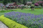
Queen Sirikit Botanical Garden covers a mountainous area of 560 acres. It is located around Km. 12 along the Mae Rim – Samoeng route. This international botanical garden was established to honor Queen Sirkit in 1992. It has a fine collection of Thai and foreign plants. The garden is set up to exhibit plants according to species and climate. Visitors can drive around the area. Places to see include the Tourist Information Centre, the Thai Orchid Breeding Centre, Herbs Museum and Research Centre. The garden offers 3 walking trails :
1) Rock Garden – Thai Orchid Nursery, takes around 30 – 60 minutes on foot ;
2) Arboreta (plant study trail), showing more than 10species of plants including banana, palm, fern , and ginger. This trail takes around 45 – 60 minutes ;
3) Climber Collection takes around 1 – 2 hours to climb the mountain.
It is open daily to the public from 08.30 to 16.00 hrs.
Ban Hmong Mae Sa Mai is a Hmong village where unchanged traditions and ways of life can be seen. It can be reached by taking a left turn at Km. 12 for 7 kilometres on a steep dirt road. Only four – wheel vehicles in good condition can make the trip.
Along the route, there are several pretty resorts decorated with flowers, which are open to visitors including Mae Sa Valley, Mae Sa Resort, which offers a 9 – hole golf course, and Kangsadan Farm. See the accommodation sheet for more information.
Mae Malai – Pai route (Highway No. 1095 off Highway No. 107)
Pong Duat Pa Pae is located in Amphoe Mae Taeng, some 40 kilometres from Chiang Mai town. The hot spring spurts out steam 4 metres above ground and is situated amid a forest that has a strong sulphuric scent. To get there, drive on Mae Malai – Pai Road for 35 kilometres and then turn right for 6.5 kilometres onto an unpaved road.
Namtok Mok Fa is a one – level cascade located on the Mae Malai – Pai road. Take a left turn left at Km. 20 onto a dirt road for 2 kilometers. It is teeming with lush green trees and full of water all year round. The delightful ambience of the waterfall makes it an ideal place for recreation.
|
|
Huai Nam Dang National Park covers an area of 180 square kilometres of Amphoe Mae Taeng, Chiang Mai and Amphoe Pai, Mae Hong Son. Most of the areas are ranged highlands. The mountain has a verdant forest, which is the source of tributaries and various streams. Attractions include :
|
Huai Nam Dang Viewpoint, Doi Kiu Lom overlooks Doi Chiang Dao and is superb spot to see sunrise amid cloudy valleys in the early morning . To get there, drive along Mae Malai – Pai Road to between Km. 65 – 66, and then take a 6 – kilometre access road to the park office.
Doi Chang Viewpoint is located 20 kilometres beyond the Huai Nam Dang Viewpoint. Only a four wheel vehicle can make the trip. The scenic views of natural mountain ranges and early morning sea of cloud can be seen from here.
Camping is possible provided that v isitors bring their own tents and food. Nearby attractions in Mae Hong Son province s uch as Pong Nam Ron Tha Pai (hot spring ) and Namtok Mae Yen (waterfall) are worth visiting.
Northeastern Route (Highway No.1001, Chiang Mai –Phrao)
Si Lanna National Park is full of wildlife and verdant forests, which are the source of various tributaries of the Mae Ping River. The park covers a mountainous area of 260,800 acres in Phrao, Mae Taeng, and Chiang Dao districts.
Attractions in Si Lanna National Park
Mon Hin Lai Waterfall, the 9 – tired waterfall is located in Mae Ngat Forest, Amphoe Phrao. It is full of water all year round and falls straight down off a mountain. The unique cascade has many outstanding levels tiers. The top tier, in particular, is an ideal viewpoint to observe the splendid landscape of Phrao district. To get there, drive on the Chiang Mai – Phrao road for 85 kilometres, turn left for 4 kilometres onto a dirt road. Only four – wheel vehicles can make the trip.
Mae Ngat Sombun Chon Dam (�������Ѵ����ó��) is located at Km. 41 on the Chiang Mai - Fang route and then turn right for 11 kilometres. The area has a very scenic forest. Privately run rafts and restaurants are available throughout the year.
Other interesting sites in the area include Huai Mae Rangong Waterfall, Huai Pa Phlu Waterfall, Pha Daeng Cave, and Doi Mae Wa Hang Natural Study Trail (it is located around 4 kilometres from the National Park office).
Getting to the park office : Drive along Highway No. 107 (Chiang Mai - Fang route), and then turn right to Sombun Chon Reservoir for 12 kilometres (on the way, there are stalls selling scented lime). No accommodation is available, but camping can be done at Huai Kum camping area, which is located near the So Ro 6 Conservation Unit, Huai Kum around Km. 260 along Chiang Mai – Fang route.
Eastern Route (Highway No. 118 and 1006)
San Kamphaeng, a district in Chiang Mai, is famous for silk and a cotton – weaving village. It is located 13 kilometres from the east of Chiang Mai town. Most of the visitors to Chiang Mai visit San Kamphaeng for souvenirs that are made from high quality but inexpensive silk and ctton. The village showcases a weaving factory as well as a silk weaving process. On the way from Chiang Mai to San Kamphaeng, there are factories and souvenir shops that sell woodcarving, silverware, earthenware, lacquerware, and cotton fabrics.
San Kamphaeng Hot Springs are located 36 kilometres from town admid natural surroundings of trees and verdant hills. The water has a high sulphur content and possesses curative and restorative properties. Accommodation, a swimming pool, dining facilities and segragated mineral water bathing rooms are available. Nearby is Roong Arun Hot Spring Resort which offers bungalows, mineral baths and a sumptupous park setting. Public transport operates from Chang Phuak bus terminal, get off at San Kamphaeng, and then ride a chartered local truck (Song Thaeo) for around 200 baht per truck.
ACTIVITIES
|
|
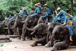
Elephant Show
An elephant show is performed in the morning from 09.40 to 10.30 hrs. The show begins with elephants bathing in the pond to cool themselves down and then mahouts would place a log harness on their backs. Finally, elephants will demonstrate their formidable forestry skills. Elephant riding and rafting are the most enjoyable activities. Elephant shows are performed at the following places :
|
Tha Phae Mae Taman is along Highway No. 107 (Chiang Mai - Fang) for 43 kilometres, t urn left for 7 kilometres.
Pang Chang Mae Taeng is on the same route to Tha Phae Mae Taman. It is 9 kilometres from the entrance and is opposite to Mae Taman temple.
Chiang Dao Elephant Training Centre is ar ound Km. 56. Coming from Chiang Mai, it is on the right. The center trains young elephants on forestry skills and is open to the public daily at 09.00 and 10.00 hrs.
Pang Chang Mae Sa is at Km. 10 to the Mae Rim – Samoeng route.
Pang Chang Pong Yaeng is located at Km. 18.5 of the Mae Rim – Samoeng route. Take the same route that leads to Kangsadan Farm.
Mountain Biking
This is a fun activity that provides both good health and a relaxed feeling. Mountain biking can be done on several routes in Chiang Mai including around the old city moats, Doi Suthep Khun Chang Khian – Huai Tung Thao, Huai Nam Dang, Huai Nam Ru, and Mae Taeng.
Homestay at Ban Mae Kampong
Ban Mae Kampong is some 50 kilometres east of Chiang Mai in Mae On district. The village is situated in a mountainous area with lush jungle surroundings. Visitors can experience real thai village culture as well as enjoy several activities. Nearby attractions include beautiful waterfalls, a cotton weaving village and the Huai Hong Khrai Royal Agricultural Station.
TREKKING TOURS
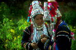
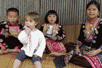
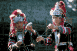
A great many of the tourists visiting Chiang Mai make enquiries about hilltribe trekking .Of particular interest to most are the six major hilltribes which inhabit the Northern Highlands. The largest group is Karen, followed by the Meo, Lahu, Yao, Akha and Lisu. They share animist beliefs and honour numerous forest and guardian spirits. Each tribe has distinctive ceremonial attire, courtship rituals, games, dances, agricultural customs, puberty rites, languages or dialects, aesthetic values and hygienic habits.
|
|
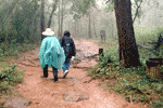
Popular ‘Jungle Treks’, lasting from 2 to 7 days, take visitors through forested mountains and high valleys and meadows, and include visits to remoter high - altitude hilltribe settlements for overnight stays. The best guides are hilltribe youths who customarily speak English, Thai and at least three tribal dialects.
|
Treks commonly feature travel by foot, sometimes by boat, elephant - back, horse – back or jeep, frequently a combination of two or three modes of transportation. Three main trekking areas, in which there are many different routes, are as follows :
a) Chiang Mai - Mae Taeng Route usually include a raft trip down the Mae Taeng River :
b) Chiang Mai – Mae Hong Son Route take adventures through spectacular mountain scenery where some roads are virtually impassable except in dry season.
c) Chiang Mai - Chiang Rai Route offers an extremely pleasant, but potentially with exciting long – tail boat ride on the Mae kok River, all the way from Tha Ton to Chiang Rai.
The other major trekking areas in the North are Chiang Dao, Pai, Mae Chaem, Mae Chan, Ngao, Phrao, Wiang Pa Pao and Lampang.
Prospective trekkers are advised to shop around companies offering such tours for the best conditions. All treks must be registered with the Tourist Police. This is done for trekkers’s protection. Avoid companies that do not abide by this law. Visitors are welcome to enquire from the Tourist Police to confirm which tour companies have negative or bad reputations, or visit the TAT Chiang Mai office to obtain a list of registered travel agents. Tourist Police is located at 75 Chiang Mai – Lamphun Road,
Also, avoid narcotics, essentially everything from ‘soft drugs’ such as marijuana to ‘hard drugs’ such as opium and heroin both during travel and at hilltribe villages. There are severe penalties for such usage.
Valuables should be deposited in the safe of your hotel of guest house while you are trekking upcountry. Wear sensible clothing to protect your limbs and sleep under a mosquito net at night. Malaria is a real threat, and sensible precautions should be taken to avoid it.
Visitors should remember to
a) respect hilltribe beliefs and religious symbols and structures.
b) Dress modestly. Hilltribe people are generally modest. Inappropriate attire may offend them.
c) Ask permission before photographing someone. Some villages do not permit photography.
d) Avoid trading western medicines and articles of clothing. Contributions to their welfare, items such as pens, paper, needles, thread, cloth and material used for embroidery are perfectly acceptable.
|
|
SHOPPING
Chiang Mai is , quite simply, Thailand’s Major centre for quality handicrafts. The visitor need visit the nearest city emporium or night market to purchase an extraordinary variety of antiques, silver jewellery, hilltribe opium pipes and embroidery, Thai silks and cottons, basketry, celadon, silverware, furniture, lacquerware, woodcarvings and parasols.
|
A major advantage of shopping in Chiang Mai is that the visitor may watch artisans working the city and in several outlying villages, particularly along the Bo Sang – San Kamphaeng Road where, in genuine cottage industries, parasols, silk and cotton weaving, jewellery, woodcarving, silverware, celadon, and lacquerware are manufactured, and number among popular purchases.
Major Chiang Mai products include :
Cottons & Silks – First – class Chiang Mai cottons and siks are of incomparable quality. Cottons and siks have innumerable fashion and furnishing applications. The largest possible selection is available in San Kamphaeng.
Umbrellas/ Parasols - These are inextricably associated with Bo Sang where villagers have been engaged in their manfacture for at least 200 years. All materials, silks, cottons, Sa paper (manufactured from the bark of the mulberry tree) and bamboo are produced or found locally. Visitors to Bo Sang will see literally hundreds of designs and sizes ranging from the miniature to the gigantic.
Silverware - The finest Thai silverware is exquisite, and is made in Chiang Mai, where certain certain families have practised their art for several generations. Traditional skills and a guaranteed content of at least 92.5% pure silver invest bowls, receptacles and decorative items with authentic value. Silver shops are concentrated on Wua Lai road, where silverware artisans and their families live.
Lacquerware - Striking black and gold designs give lacquerware its visual appeal and sheen. This decorative are enhances items made of wood, bamboo, metal, paper and baked clay, in the form of receptacles, ornaments and various souvenirs.
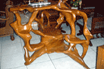
Furniture/Woodcarving – Chiang Mai’s Ban Thawai village in Hang Dong district, is a major centre of furniture making. Major woods and materials include teak, rosewood and rattan. Items may be unadorned or, especially with teak and rosewood, artfully carved in traditional or modern designs. Woodcarving is a traditional northern Thai art featured in numerous temples. In recent years, wood carving has increasingly embellished furniture, gracing screens, chairs, tables, beds, indeed anything bearing a wooden surface large enough to be carved. Carved elephants, figurines and tableware number among other popular purchases.
Hilltribe Products – These include silver ornaments, such as bracelets, necklace, pendants and pipes of intricate design, and embroidered items including tunics, jackets, bags, purse, caps and dress lengths.
Gold Plated Orchids & Butterflies - Orchids and butterflies are preserved and plated with 24 – carat gold to create unusual gift items such as necklace pendants, hairpins and earrings.
Pottery – Chiang Mai is the major centre of Thailand’s pottery industry. Prized items include high – fired celadon which is produced in many forms, including dinner sets, lamp bases and decorative items. |
|
FESTIVALS
Songkran Festival is held annually from 13 to 15 April. The 13th of April is the Great Songkran day featuring the revered Phra Phutthasihing Buddha image parade around Chiang Mai town for bathing, sand pagoda making, blessing of elders, and water splashing.
|
Bo Sang Umbrella Festival is held in January in Bo Sang Handicraft Center. The festival features paper products, paper parasols in particular, cultural shows, a parade showing traditional ways of life, and several contests.
Flower Festival is held in February. The festival includes ornamental garden flower contests, floral floats parade in the morning and beauty pageants. The parade begins at Chiang Mai Railway Station and passes Nawarat Bridge and ends at ends at Nong Buak Hat Park.
Doi Suthep Pilgrimage On the night of Visakha Bucha Day, worshippers gather to light candles and make the 7 – kilometre pilgrimage up to the temple on Doi Suthep.
City Pillar Inthakin Festival is held to invoke blessings of peace, happiness and prosperity for the city and its residents. Buddha images are paraded around the city. In is held at Wat Chedi Luang for 7 auspicious days and nights in the 7the lunar month.
Yi Peng Festival is held annually on Loi Krathong day . It is a very interesting event of Chiang Mai. The festival features the release of lanterns into the sky to worship the gods. There a re also fireworks, lantern contests, and beauty pageants.
|
|
 LOCAL TIME
GMT + 7 hours |
 ELECTRICITY
220 Volts 50 cycles throughout the country. |
|

|